Severe weather forecast for Saturday expands
Team Radio Marketing Group - October 20, 2017 11:34 am

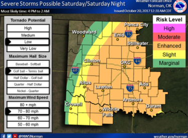
The forecast for severe weather on Saturday has expanded the Enhanced Risk area to the west. Much of the state is included in this area, Ponca City Emergency Management Director Paula Cain said Friday morning.
“Storm timing for the Ponca City area is between 7 and 10 p.m.,” Cain said. “Risks continue to include damaging winds up to 80 mph and hail up to the size of tennis balls. Both of these can cause significant damage to personal property, trees, etc., and create dangerous flying debris.
“Supercells are expected to develop along and ahead of the cold front as it moves through the state,” Cain said. “Although the tornado risk is low, they are more likely to develop during the early storm initiation. Heavy rain is also possible, causing flash flooding. Flooding is the No. 1 cause of deaths related to severe weather.”
Cain said that most storm-related injuries are caused by flying debris.
“Eighty mph winds are dangerous,” she said. “Wherever you are tomorrow, make sure there is adequate shelter readily available after 7 p.m., and don’t let storms catch you off guard.”
NWS has provided this video update on Saturday’s severe weather:


