Severe storms possible for the rest of Tuesday
Ponca City Now - May 7, 2019 3:53 pm

Severe weather is possible through the rest of the day Tuesday and into the night, according to Emergency Management Director Paula Cain.
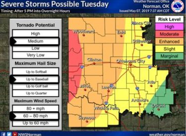
“There are four risk levels on this map,” Cain said. “Moderate Level is the most severe, and I honestly don’t remember when we last had a moderate risk in Oklahoma. I think it has been a couple of years. The Moderate Risk is in far western Oklahoma, and corresponds to the condition potentials listed on the left. So in the moderate area there will be a chance of baseball size hail, winds up to 80 mph and a medium tornado potential.
“This means that there is potential to see a LOT of tornadoes develop in this area, but not necessarily their strength. Super cell thunderstorms are expected in the area based on conditions, so larger tornadoes are possible. If large, super cell tornadoes do develop, they could move well past the area outlined as Moderate. Don’t expect them to suddenly stop,” she said.
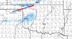
 “In the second graphic, you see a blue and red line at the east end of the panhandle. This is the location of initial storm development and what you want to watch to get a better idea of storm timing across the state,” Cain said.
Ponca City storms are forecast to reach the area after 10 p.m., but this will depend on the timing of the initial storms, she said.
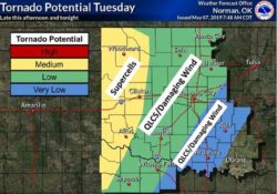
“We have a Low Tornado risk; hail is still possible, but more likely quarter to fifty-cent size,” she said. “Wind speeds may not vary much, reaching 65-75 mph. There is a chance of some flash flooding as well. As thunderstorms move across the state they will probably develop into a squall line, which translates to continued very strong winds, weaker tornadoes but harder to identify on radar.
 “IF a tornado warning is issued tonight, you should go immediately to your selected shelter. (PS: QLCS refers to those squall line tornadoes.) It will not be surprising if storms linger into the early morning hours,” Cain said. “Be ready for severe weather by having a response plan for you and your family.
- Storms will start in western OK sometime after 3 pm.
- Tornadoes are possible
- Tornadoes in our area will be quick spin-ups & short lived
- Very strong winds will accompany storms as they move across the state
- Hail sizes will shrink as the air cools


